
South Texas Heat Wave Breaks: Pattern Shift Brings Cool Relief by Next Week
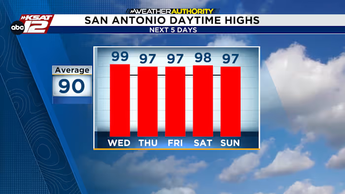
A persistent late-season heat dome over South Texas is finally showing signs of releasing its grip, with meteorologists forecasting a significant pattern shift that could deliver much-needed cooler temperatures and scattered rain chances starting as early as next week. After a grueling stretch of near-record temperatures, residents across San Antonio and the broader South Texas region can look forward to a reprieve — though not before one more scorching day Wednesday.
Late-Season Heat Stretch Pushes Temperatures to Extremes
South Texas is experiencing what forecasters are calling a remarkable late-season heat event. Wednesday could mark the sixth consecutive day with temperatures at or near 100 degrees across much of the region, a streak that has left many residents seeking relief indoors and prompting health officials to issue heat advisories. The heat high — a dome of elevated atmospheric pressure that traps hot air near the surface — has been the primary driver behind these sweltering conditions, steering clear skies and oppressive warmth across the Texas Hill Country and surrounding areas.
What makes this particular heat wave notable is its timing. Late September typically signals the beginning of a gradual cooldown across Central and South Texas, making this prolonged stretch of triple-digit temperatures a rare and unwelcome anomaly. The record-setting late-season heat has tested the endurance of even the most heat-adapted residents, with little overnight recovery as nighttime lows have also remained elevated.
Thursday Rain Chance Offers Brief Respite
While Wednesday is expected to bring more of the same scorching conditions, Thursday offers a glimmer of hope. A surge of moisture moving into the region is forecast to produce a 20% chance of scattered showers during the afternoon hours. Though the rain chances remain relatively low, forecasters say the added cloud cover and increased humidity should be enough to knock temperatures down a few degrees — providing at least a temporary cooling effect beneath the heat dome.
Even without widespread rainfall, the modest increase in atmospheric moisture could make the ambient feel slightly less punishing for those heading outdoors. Any brief showers that do develop are expected to be isolated rather than widespread, but the change in atmospheric pattern could serve as a precursor to the more significant weather shift on the horizon.
The Pattern Shift: Relief Arrives by Monday
The most anticipated development on the forecast horizon is the expected pattern shift that could arrive as early as Monday. Meteorologists are closely monitoring the positioning of the heat high pressure system, which is forecast to begin shifting or weakening over the coming days. While the ridge may not move entirely out of the region, even a subtle repositioning could be enough to stir up isolated showers and storms and allow temperatures to drop to more seasonable levels.
By Monday, forecasters anticipate less intense heat and an increased likelihood of rain across the forecast area. This would mark a dramatic reversal from the current heat wave and align with the broader seasonal transition that South Texas residents expect at this time of year. The extended outlook suggests that while the cooling may not be immediate or uniform, the direction of the trend is clearly toward more comfortable conditions.
Forecast Highlights:
- Late-Season Stretch: Wednesday could be the 6th day in a row at or near 100° for many locations across South Texas.
- Thursday Rain Chance: A 20% shot at scattered showers Thursday afternoon, bringing modest cooling through cloud cover and humidity.
- Pattern Shift: By Monday, expect less-hot temperatures and increased rain chances as the heat high begins to shift.
Fall Officially Begins: A Seasonal Turning Point
This is South Texas’s last full week of summer, as fall officially begins on Tuesday with the autumnal equinox. The timing of the current heat wave is particularly notable given that it coincides with the seasonal transition, making the contrast between the lingering summer heat and the approaching cooler months even more pronounced.
The fact that this record-setting heat is occurring at the tail end of summer — rather than during the peak of July or August — makes it all the more striking for meteorologists and residents alike. As the heat high pressure system begins its expected shift, the transition into fall could arrive with a welcome burst of cooler air and scattered storms, effectively wrapping up the summer’s most extreme weather episode.
For those eager to know when the South Texas weather will finally cool down, Monday’s forecast represents the best opportunity for meaningful relief. While isolated showers and storms may begin as early as this weekend, the broader cooldown is expected to solidify as the week progresses and the atmospheric pattern settles into a more typical fall configuration.
What to Expect in the Days Ahead
Looking at the extended forecast, the coming week promises a gradual but noticeable improvement in conditions. Residents can anticipate:
- Wednesday: Continued extreme heat with temperatures near or above 100 degrees across much of the region.
- Thursday: Partial cloud cover and a 20% chance of afternoon showers, with temperatures running slightly cooler.
- Weekend: Increasing instability as the heat high shifts, with isolated storm potential.
- Monday onward: More significant cooling and improved rain chances as the pattern shift takes hold.
The coming days will be critical in determining exactly how much relief the region receives and how quickly the transition away from summer heat unfolds. While the heat high may not depart entirely, its repositioning could be enough to restore more typical late-season temperatures and provide South Texas residents with the cooling they have been awaiting.
About the Authors
This forecast is provided by the KSAT Weather Authority team, led by Justin Horne, a meteorologist and reporter for KSAT 12 News who covers severe weather across South Texas, and Sarah Spivey, a San Antonio native and longtime KSAT meteorologist who has been a member of the Weather Authority Team since 2017.
The KSAT meteorologists continue to monitor the evolving atmospheric pattern and will provide updated forecasts as the heat high’s movement becomes clearer. For the latest South Texas weather updates, follow KSAT 12 News for real-time coverage throughout the week.
Categories: Weather, News, South Texas, San Antonio, Heat Wave, Fall Weather, Forecast, Meteorology, KSAT-12, Texas Weather

