
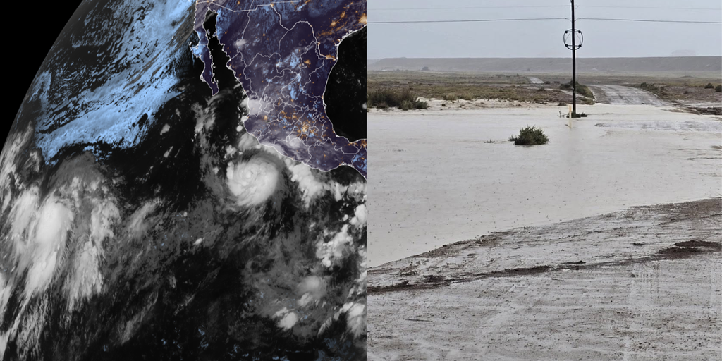
Hurricane Polo Threatens Southwest as Pacific Season Surges
Hurricane Polo, originally a tropical storm off Mexico’s southwestern coast, has rapidly evolved into a major hurricane and is now reshaping weather patterns across the western United States. The storm’s intense rainfall is amplifying existing monsoon activity, raising the risk of life‑threatening flash floods in the Southwest, while also setting the stage for additional tropical development in Hawaii and the Central Pacific.
Polo’s Rapid Intensification and Flood Risk
When Polo formed late Sunday, it was a modest tropical storm with sustained winds near 60 mph. By Monday afternoon the National Hurricane Center (NHC) had reclassified it as Hurricane Polo, with winds already at 80 mph. Forecasters now expect the system to become a Category 3 or stronger hurricane by Wednesday, marking a classic rapid intensification episode fueled by warm waters and favorable upper‑level conditions.
The storm is currently situated roughly 270 miles southwest of Mexico’s southwestern coastline, moving east at 5 mph. While a direct U.S. landfall remains unlikely, Polo’s moisture is already being pulled northward, intensifying the monsoon’s heavy rain bands over the Southwest. The National Weather Service in Albuquerque warns that “widespread heavy rainfall will lead to a risk of life‑threatening flash flooding across much of the state.”
Impact on New Mexico’s Monsoon and Flash Flooding
Starting Tuesday, a Level 3 out of 4 flash flood threat will cover parts of southern New Mexico, including Las Cruces. The threat will shift north and east on Wednesday, encompassing Roswell and bringing heavy rain to Albuquerque. The flood risk stems from a combination of monsoon thunderstorms and the extra moisture Polo is funneling into the region.
Earlier in September, a separate tropical disturbance sparked flooding that claimed three lives near Newcomb, New Mexico. The National Weather Service now warns that Polo’s enhanced moisture could produce even more dangerous conditions, especially in low‑lying and canyon‑lined communities where runoff can become a “flash flood highway.” Emergency managers have urged residents to prepare for possible evacuations and to monitor river gauges across the Rio Grande basin.
Rescue crews have already begun pre‑positioning equipment, and the Maricopa County Sheriff’s Office deployed a helicopter to evacuate motorists stranded in floodwater on Sept. 16, underscoring the immediacy of the threat. Authorities stress that “any amount of rapid water rise can be deadly,” and they advise residents to “turn around, don’t drown” when encountering flooded roadways.
Odalys and the Potential for Southwest Interaction
While Polo dominates headlines, the open Pacific is also host to Tropical Storm Odalys, currently more than 1,000 miles southwest of Baja California. Odalys carries sustained winds of 45 mph and is forecast to gradually strengthen into a hurricane by midweek. The storm’s projected track points it back toward the Mexican coast later in the week.
Current Status of Tropical Storm Odalys
According to the latest NHC updates, Odalys is moving west‑northwest and is expected to regain hurricane status as it encounters warmer sea‑surface temperatures. Forecast models show a possible interaction with Polo, though the two systems are far apart at present. “Some computer forecasts show Odalys interacting with Polo in some fashion in several days,” says FOX Weather Hurricane Specialist Bryan Norcross. If the storms do engage, the combined moisture could further boost rainfall over the Southwest.
Even without direct interaction, Odalys will contribute additional tropical moisture to the region, heightening flood concerns across Arizona, New Mexico, and parts of Texas. Emergency managers are monitoring the system closely, especially given the recent spate of heavy rains that have saturated soils.
Hawaii’s Warning: Remnants of Tropical Depression Fifteen‑E
Hawaii, a state that rarely experiences tropical activity, is now in the crosshairs of the remnants of former Tropical Depression Fifteen‑E. The system, located east‑southeast of the islands, is moving westward and has a growing chance of re‑organizing into at least a tropical depression.
Potential Heavy Rainfall for the Islands
Even if Fifteen‑E does not fully re‑intensify, it will still dump heavy rain across the islands beginning Wednesday. Forecasts indicate 8–12 inches of precipitation could fall over the Big Island, with Hilo expected to receive some of the heaviest totals. Wind gusts may reach 30–40 mph as the system passes nearby.
Recent Hurricane Lala, a Category 1 storm, already left extensive damage across the southern end of the Big Island, and the residual effects of that system are still being assessed. Emergency officials warn that the new rainfall could trigger mudslides in mountainous areas, especially where soil is already saturated from previous storms.
A specialized weather unit from the National Weather Service has issued a multi‑day flash flood outlook for Hawaii, urging residents to prepare for possible road closures and power outages. The state’s “Ready Hawaii” campaign emphasizes staying informed and having evacuation plans ready.
El Niño Drives Unprecedented Pacific Activity
The surge in tropical systems is not an accident. The eastern and central Pacific have recorded 18 named storms this season, a figure that reflects the rapid strengthening of El Niño conditions. El Niño’s warm ocean surface waters fuel more atmospheric instability, allowing tropical cyclones to form and intensify with greater frequency.
Context for the Record‑Breaking Storm Count
El Niño’s influence extends beyond the number of storms; it also affects their tracks and intensities. Warm waters in the central Pacific have provided the energy needed for rapid intensification events like Polo, while also creating conditions conducive to the development of smaller, short‑lived systems such as Fifteen‑E. The National Oceanic and Atmospheric Administration (NOAA) reports that the odds of a “super‑El Niño”—a category with near‑100 % probability of sustaining strength through the winter—are currently at 100 %.
This heightened El Niño activity is also linked to altered jet‑stream patterns that can amplify monsoon moisture over the southwestern United States, compounding flood risks. Scientists warn that the combination of a strong El Niño and an already active Pacific basin could set the stage for an especially stormy winter, with potential impacts extending into early next year.
What to Expect Next in the Pacific Basin
While Polo and Odalys command much of the attention, the NHC continues to monitor an additional area for potential development south of the Gulf of Tehuantepec, several hundred miles southwest of Polo. This region has medium odds of tropical cyclogenesis over the next seven days, according to the latest advisories.
Forecasters stress that the Pacific’s active pattern is likely to persist, offering little respite for communities already coping with storm impacts. Residents along the U.S. Southwest and Hawaii are advised to stay updated on the latest forecasts and to have emergency plans in place.
As the season marches on, the interplay between El Niño, warm ocean temperatures, and atmospheric conditions will continue to shape the Atlantic and Pacific basins. Ongoing research aims to improve rapid intensification forecasts, but for now, vigilance remains the best defense against the storms’ increasingly dangerous impacts.
Stay informed by checking the National Hurricane Center and National Weather Service updates, following local emergency management agencies, and heeding any evacuation orders that may be issued as these systems evolve.
News,Science,Government,Health,Society,Communities

