
Philadelphia Under Threat of Severe Storms This Week – What Residents Need to Know
As parts of the Philadelphia area recover from a ferocious overnight storm that uprooted trees and knocked out power, meteorologists are issuing new warnings about potentially even more dangerous weather arriving later this week. The National Weather Service has confirmed that the entire Philadelphia region faces the possibility of severe storms on Wednesday, bringing damaging winds and heavy downpours that could disrupt daily life across the metropolitan area.
Immediate Danger Looms Over Philadelphia as Powerful Storms Approach
The latest forecast indicates that the Philadelphia area has the potential to experience severe weather on Wednesday, including damaging winds and significant rainfall. These storms are expected to move into the region during the late afternoon and early evening hours, creating hazardous conditions for drivers and outdoor activities alike.
Forecasters emphasize that while the storms are described as mostly isolated, their arrival could bring substantial disruption. Temperatures will be cooler on Wednesday, but lingering humidity will keep atmospheric conditions favorable for further storm development. The combination of cooler air masses meeting moist, unstable conditions creates the perfect recipe for severe weather events that can cause structural damage and safety hazards.
Beyond Wednesday: Thursday and Friday Storm Activity and Temperature Changes
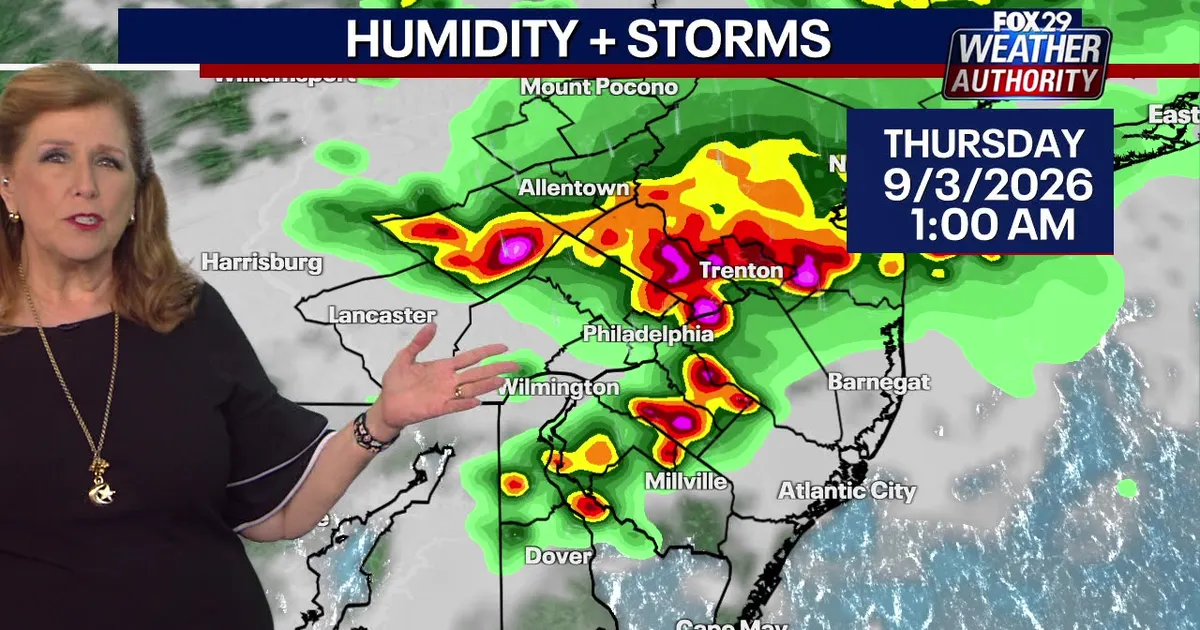
Looking ahead, strong isolated storms are projected to continue forming overnight, with the most advanced models pointing to areas along the I-95 corridor—including Philadelphia and Trenton—as being particularly affected. This extended period of severe weather is expected to persist through Thursday and Friday, offering residents a chance to prepare for continued precipitation and potential flash flooding risks.
As the storm system moves eastward, temperatures are anticipated to rise into the 90s Fahrenheit, accompanied by persistent muggy humidity. This warm, wet environment supports the likelihood of scattered rain showers continuing through Friday, eventually giving way to some sunny intervals before the weather pattern shifts.
Local Impact Recap: Storm Damage and Recovery Efforts in PA and NJ
Building on the recent storm event that caused widespread disruption, the aftermath has left lasting effects across Pennsylvania and New Jersey. The ferocious storms prompted multiple severe weather alerts from the National Weather Service, including a notable tornado warning issued in Burlington County. While no tornado was confirmed to have made landfall as of Wednesday morning, the warnings served as a critical reminder of the dangers still lurking in the region.
Residents experienced power outages due to downed trees and strong winds that toppled power lines across both states. Delaware was not spared either, with reports of a lightning strike at a home in Dover that ignited a fire, highlighting the diverse ways severe weather can manifest across the Northeast.
From Past Storms to Current Conditions: Lessons Learned
The recent storm event underscores the importance of weather preparedness in the Philadelphia area. Power outages and travel disruptions were common experiences during the earlier storm, with many residents relying on emergency generators and alternative heating solutions. Emergency management officials have stressed the need for families to have backup plans, including communication strategies and evacuation routes in case of worsening conditions.
Authorities recommend staying informed through official channels, monitoring local news outlets, and having essential supplies ready. The continuity of severe weather through the remainder of the week means that residents should remain vigilant and adapt their routines accordingly.
Conclusion and Looking Forward
The coming days will test the resilience of communities across Philadelphia, New Jersey, and surrounding areas as severe storms continue to develop. While the immediate danger peaks on Wednesday, the prolonged nature of the weather system means that preparation efforts should extend beyond that single day. Residents are encouraged to follow official advisories, secure outdoor equipment, and maintain safe distances from downed power lines. As the forecast progresses, the combination of cooler temperatures and lingering humidity will shape the intensity and duration of these weather events, making thorough planning essential for a smooth transition to clearer skies.
News, Communities, Science

