

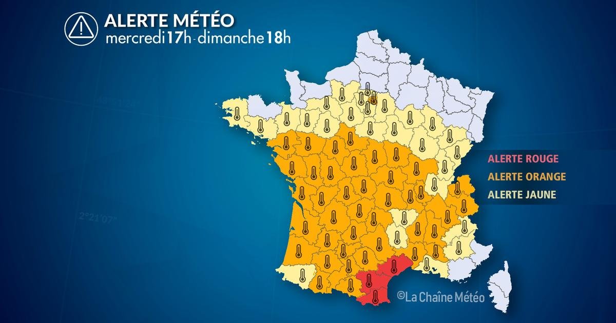
From Wednesday 8 July at 17:00. until Sunday, July 12 at 6:00 p.m.
Situation
There is an extensive anticyclone over Western Europe and France. The thermal dome associated with this anticyclone extends from the Iberian Peninsula to the west and south of France. This dome of heat should reign over the country at least until the beginning of the week.
The very hot weather will spread into the north and north-east later in the week, with more departments affected by our heatwave warning. The heat will increase from the southwest into the central regions, which could lead to an extension of our red alert. The Paris region may also move to the red alert level..
At this moment, no real drop in temperature is expected. The heat wave will last until at least July 15..
At the same time, increasing drought continues in many regions, increasing the risk of wildfires and fires affecting vegetation.
Air quality is also degraded by high ozone concentrations fueled by intense and prolonged heat.
Observation
This Wednesday It is very hot in the south, especially in the Lion Bay area. 7 absolute records and 37 monthly records were set.
Maximum temperature recorded this Wednesday:
– 43°С in Moules et Bocell (34)
– 42.6°C in Prades-les-Leses (34)
– 42.5°C in Villevieille (30)
– 42.3°C in Saint-Christol-les-Alès (30)
– 41.8°C in Argelies (11)
– 41.6°C in Montarno (34)
– 41.5°C in Nimes – Courbesac (30)
– 41.5°C in Salindres (30)
– 41.2°C in Kadena (84)
– 40.8°C in Perpignan (66)
– 40.8°C in Montpellier (34)
– 40.6°C in Istra (13)
Several absolute records of this environment:
– 41.4°C in Caen-en-Roussillon (66)
– 41°С in Sete (34)
– 40.5°C in Beziers (34)
– 40.5°C in Marignane (13)
– 40.2°C in tears (66)
– 39.9°C in Cassis (13)
This Wednesday at noon, Extreme heat is widespread throughout the region. In the south of the country, especially in the Gulf of Lyon area, it is already very hot at noon.
We note:
– 40.6°C in Fita (11)
– 39.8°C in Saint-Christol-les-Hales (30)
– 39.8°C in Ser (66)
– 39.6°C in Moula e Bosel (34)
– 39.4°C in Canet-en-Roussillon (66)
– 39.4°C in Perpignan (66)
– 39.2°C in Villevieille (30)
– 39.2°C in Générargues (30)
– 39.1°C in Vives (66)
– 39°C in Nimes (30)
This Wednesday morning minimum temperatures are exceptional in the south.
We note:
– 29°C in boxes (66)
– 27.7°C in Cap Beard (66)
– 26.9°C in Vives (66)
– 26.6°C in Perpignan (66)
– 25.8°C in Pertus (66)
– 25.4°C in Sumon (34)
– 25.1°C in Ser (66)
On Tuesday we celebrated 67 monthly records in the country.
We noted that at maximum temperatures:
– 41.5°C in Monpazier (24)
– 41.4°C in Beaulieu-sur-Layon (49)
– 41.4°C in Saumur (49)
– 41.3°C in white (36)
– 41.3°C in La Couronne (16)
– 41.2°C in Sauternes (33)
– 41.1°C in Arquette-en-Val (11)
– 41°C in Saintes (17)
– 40.8°C in Bordeaux (33)
– 40.8°C in Pissos (40)
Find out the weather in your city
Evolution
THURSDAYwith the heat, which will continue to intensifyour services must place other departments on the RED alert level..
In departments where the orange alert level has been declared, the maximum temperature reaches 35-40°C. At night the temperature usually does not drop below 20–24°C.
Friday, lows are getting higher and higher in the north, as well as in the south, with temperatures never falling below 20-24°C. The very hot weather will increase in the north and northeast this afternoon, with 33 to 36°C from the Paris Basin to Alsace and 35 to 40°C in the larger western half of the country.
This weekendThe heat wave continues with very high lows (widespread tropical nights) and very hot weather in many regions. This heatwave is expected to peak between Sunday and Monday, with maximum temperatures likely to reach 40-43°C.
At this momentNo real drop in temperature is expected early next week. This massive heat wave will last until around July 15th.