
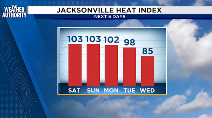
Weekend Storms and Dangerous Heat Grips Northeast Florida and Southeast Georgia
Northeast Florida and southeast Georgia are in for an active weekend of weather as showers and thunderstorms continue to develop along the Gulf and Atlantic sea breezes. While overall storm coverage may be slightly less than recent days, residents should still plan for locally heavy rainfall, gusty winds, and dangerously high heat indices that could push the “feels like” temperature well above 100°F.
This forecast covers the Jacksonville metropolitan area, the I-95 corridor, and surrounding regions through the weekend and into next week, including the latest tropical outlook from the National Hurricane Center.
Weekend Storm Chances: Saturday Heavier Than Sunday
Scattered thunderstorms will dominate the weekend forecast, though the coverage and intensity will shift between Saturday and Sunday. According to the latest forecast data, Saturday brings storm chances of 40 to 60 percent for northeast Florida and 30 to 50 percent for southeast Georgia, making it the wetter day of the two.
Sunday sees a slight pullback in storm coverage, with probabilities dropping to 30 to 50 percent for northeast Florida and just 10 to 20 percent for southeast Georgia. However, the risk of locally heavy rainfall remains in effect for both days, meaning some neighborhoods could see significant downpours while others stay mostly dry.
- Saturday: Patchy fog early, then partly cloudy skies. Afternoon showers and thunderstorms likely. Morning lows in the 70s to low 80s; highs in the 80s to low 90s. Southwest/southeast winds at 10 to 15 mph.
- Sunday: Sea breeze-driven showers and thunderstorms. Lows in the 70s; highs in the 80s and 90s. Southwest/southeast winds at 5 to 10 mph.
Tonight, expect showers and thunderstorms to fire along and near I-95 before drifting inland through 11 p.m. Partly cloudy skies and patchy fog will linger overnight.
Heat Index Values Push Into Dangerous Territory
While storm chances offer some relief, the bigger concern may be the heat. Temperatures are trending above average across the region this weekend, and the combination of high humidity and summer heat will drive Feels Like temperatures between 100 and 106 degrees.
These are not just uncomfortable conditions — they pose genuine health risks, particularly for the elderly, young children, outdoor workers, and pets. The National Weather Service typically issues Heat Advisories when heat index values are expected to reach or exceed 105°F, and those thresholds are within easy reach this weekend.
Residents are encouraged to stay hydrated, limit prolonged outdoor activity during peak afternoon hours, and check on vulnerable neighbors and family members. Never leave children or pets inside parked vehicles, even for brief periods.
Tropical Development Possible Late Next Week in the Caribbean
While the Atlantic basin remains quiet in the short term, the GFS weather model continues to show possible tropical development late next week in the Caribbean Sea. The National Hurricane Center is currently keeping the seven-day outlook free of designated systems, but the situation bears close watching.
It is important to emphasize that this is a preliminary forecast — tropical weather in the Caribbean can evolve rapidly, and models frequently shift the potential for development over the course of just a few days. However, the early signal is one that meteorologists in the region will be tracking closely as we move through the weekend and into next week.
The tropics remain a watch-and-wait situation for now. Anyone in northeast Florida and southeast Georgia should stay familiar with their local hurricane evacuation zones and emergency supply kits as we enter the peak of the Atlantic hurricane season.
Next Week: Northeast Winds, Rough Surf, and Rising Rip Current Risks
Looking beyond the weekend, an upper-level northeast wind return is expected early next week, bringing noticeably breezy conditions along the beaches. These winds will fuel rough surf conditions and increasing rip current risks along the coastline.
Rip currents are the leading hazard at surf beaches, and even strong swimmers can be caught off guard by a sudden channel of water pulling away from shore. The National Weather Service recommends swimming near a lifeguard and always checking local beach forecasts before heading to the shore. If caught in a rip current, experts advise swimming parallel to the shoreline rather than directly back toward the beach.
Overall, next week’s pattern shifts toward near-seasonal temperatures with the persistent northeast wind making for a more dynamic coastal forecast compared to the calm, humid weekend ahead.
Tonight’s Overnight Forecast and Key Sunrise and Sunset Times
For those planning early activities this weekend, here are the key details:
| Detail | Value |
|---|---|
| Tonight | Showers and thunderstorms near/along I-95, then drifting inland through 11 p.m. Partly cloudy with patchy fog overnight. |
| Sunrise | 7:10 a.m. |
| Sunset | 7:36 p.m. |
The roughly 12½ hours of daylight this weekend offer a solid window for outdoor plans in the morning before afternoon storms have a chance to develop. Morning fog may be a factor at sunrise, so drivers should use low beams and reduce speed on area roadways.
Stay Informed and Weather-Ready
With a mix of heavy rain potential, extreme heat, possible tropical development, and hazardous coastal conditions all in play over the coming days, weather awareness is essential for residents across northeast Florida and southeast Georgia. Keep an eye on updates from the National Weather Service Jacksonville office and the National Hurricane Center throughout the weekend.
Whether you are planning a beach day, an outdoor event, or simply your commute, understanding the evolving forecast will help you stay safe and prepared as the region navigates an active weather pattern.
Copyright 2026 by WJXT News4JAX – All rights reserved.
News, Weather Forecast, Severe Weather, Jacksonville Florida, Northeast Florida, Southeast Georgia, Tropical Weather, Storm Tracking, Heat Index, Rip Current Safety, National Hurricane Center, Weekend Weather, Atlantic Basin, GFS Model, Summer Storms, Beach Weather, Health, Science, Society, Travel

